
Ebola Spillover Risk
A new preprint led by CERI researchers Dr Monika Moir and Professor Houriiyah Tegally and colleagues looks beyond the environmental conditions traditionally used to predict where Ebola spillover may occur. The researchers combine ecological suitability with human-driven factors that can increase opportunities for contact between people and wildlife – including mining, bushmeat activity, human settlement, forest loss and conflict.
The work is particularly relevant to the 2026 Bundibugyo virus outbreak in the Democratic Republic of Congo, which emerged in Ituri Province, a region where ecological suitability intersects with mining-related mobility, conflict, food insecurity and rainforest environments. The researchers found that incorporating these human factors improved the ability of their models to predict historical spillover locations, with mining showing the largest and most consistent contribution over the past decade.
Read the full paper, and list of authors, here
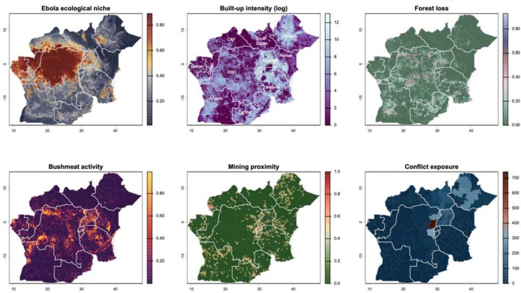
Figure (above): Spatial distribution of ecological and anthropogenic drivers of orthoebolavirus spillover risk across the DRC and neighbouring countries.
Maps show six key variables integrated to predict spillover and transmission risk in eastern DRC.
Top left: orthoebolavirus ecological niche – updated 2026 modelled habitat suitability for orthoebolavirus circulation.
Top middle: built-up intensity – nighttime light-derived settlement intensity, quantifying human population concentration and urbanisation patterns.
Top right: forest loss – proportion of forest cover loss between 2000–2025, indicating habitat fragmentation and land-use change that may alter human–wildlife contact patterns.
Bottom left: bushmeat activity – spatial density of bushmeat hunting and wildlife exploitation activity.
Bottom middle: mining proximity – distance-weighted proximity to active artisanal and large-scale mining sites, with warmer colours indicating closer proximity to mining operations.
Bottom right: conflict exposure – conflict intensity based on conflict events aggregated over 2000–2026, with darker colours indicating higher cumulative conflict exposure.
News date: 2026-09-03
Links:
KRISP has been created by the coordinated effort of the University of KwaZulu-Natal (UKZN), the Technology Innovation Agency (TIA) and the South African Medical Research Countil (SAMRC).


Location: K-RITH Tower Building
Nelson R Mandela School of Medicine, UKZN
719 Umbilo Road, Durban, South Africa.
Director: Prof. Tulio de Oliveira